A Complete Guide to Indian Geography: Physical, Political & Climatic Features
India is a land of breathtaking diversity—geographically, culturally, and climatically. Located in South Asia, India is the 7th largest country in the world by area and the most populous nation as of 2025. From the towering Himalayas in the north to the vast coastline in the south, Indian geography plays a crucial role in shaping the country’s economy, biodiversity, and daily life.
In this blog, we will explore the complete geography of India including physical features, rivers, states, climate zones, and more. If you’re a student, a UPSC/SSC aspirant, or a curious reader, this is your go-to resource for Indian Geography.
🗺️ 1. Location and Boundaries
India lies entirely in the Northern Hemisphere between:
Latitudes: 8°4’N to 37°6’N
Longitudes: 68°7’E to 97°25’E
Neighbors: India shares borders with:
Pakistan (NW), China and Nepal (North), Bhutan (NE), Bangladesh and Myanmar (East)
Maritime borders with Sri Lanka, Maldives, and Indonesia
Coastline: Approximately 7,516 km (includes mainland and island territories)
⛰️ 2. Major Physical Divisions of India
Indian Geography can be broadly divided into six physical regions:
🔹 a. The Northern Mountains
The Himalayas: World’s highest mountain range
Divided into:
Greater Himalayas (Himadri) – Mount Everest (shared with Nepal)
Lesser Himalayas (Himachal) – Famous hill stations like Shimla and Manali
Shiwalik Hills – Outermost range
🔹 b. The Northern Plains
Formed by alluvial deposits from the Ganga, Brahmaputra, and Indus rivers
Extremely fertile, agriculturally rich
Densely populated (Uttar Pradesh, Bihar, West Bengal)
🔹 c. The Peninsular Plateau
Comprises the Deccan Plateau, Chotanagpur Plateau, and Malwa Plateau
Rich in minerals and forests
Divided by the Vindhya and Satpura ranges
🔹 d. The Indian Desert
Thar Desert in Rajasthan
Arid climate, sand dunes, and sparse vegetation
Major cities: Jaisalmer, Bikaner
🔹 e. The Coastal Plains
Eastern Coastal Plain (Coromandel Coast)
Western Coastal Plain (Konkan and Malabar Coast)
Fertile deltas: Godavari, Krishna, Kaveri
🔹 f. The Islands
Andaman & Nicobar Islands (Bay of Bengal)
Lakshadweep Islands (Arabian Sea)
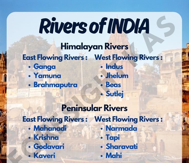
India is blessed with a vast river system, categorized into:
Himalayan Rivers
Ganga – Longest river in India
Yamuna, Brahmaputra, Indus (now mostly in Pakistan)
Peninsular Rivers
Godavari – “Dakshin Ganga”
Krishna, Kaveri, Narmada, Tapi, Mahanadi
River systems are crucial for irrigation, drinking water, hydroelectricity, and transportation.
🧭 4. Indian States & Union Territories
India is divided into:
28 States
8 Union Territories
Each state has its own capital, cultural identity, and often its own language. Key states in terms of geography:
Rajasthan – Largest by area
Goa – Smallest by area
Uttar Pradesh – Most populous
Sikkim – Least populous
☁️ 5. Climate Zones of India
Indian geography contributes to a diverse climate, from snowy winters in the north to tropical heat in the south.
Major Climate Types:
Tropical Wet (Kerala, coastal regions)
Tropical Dry (Rajasthan)
Temperate (Himalayan states)
Mountain Climate (Ladakh, Himachal)
Seasons in India:
Winter: December to February
Summer: March to May
Monsoon: June to September
Post-monsoon/Autumn: October & November
🌿 6. Natural Vegetation and Wildlife
India is home to:
Tropical Rainforests (Western Ghats, Northeast India)
Deciduous Forests (Central India)
Thorny Scrublands (Rajasthan)
Alpine Forests (Himalayan region)
Famous national parks:
Jim Corbett, Sundarbans, Kaziranga, Ranthambore, Gir
🏗️ 7. Economic & Strategic Importance
Agriculture thrives in fertile plains and river valleys
Industries are based near plateaus and mineral belts
Ports on both coasts: Mumbai, Chennai, Kolkata, Kochi
Strategic defense via Himalayas and coastal surveillance
🧠 Why Study Indian Geography?
Understanding Indian geography is vital for:
Competitive exams (UPSC, SSC, Banking, etc.)
Career in civil services, teaching, or journalism
Better understanding of natural disasters, climate change, and regional planning
General knowledge enhancement
✅ Conclusion
The geography of India is vast and fascinating, filled with contrasts in terrain, culture, and climate. From the snow-capped Himalayas to the sun-kissed beaches of Kerala, India’s physical diversity is matched by its cultural richness. Whether you’re preparing for an exam or just love learning, mastering Indian geography will deepen your understanding of one of the most vibrant nations on Earth.

Good job 👍
Good job